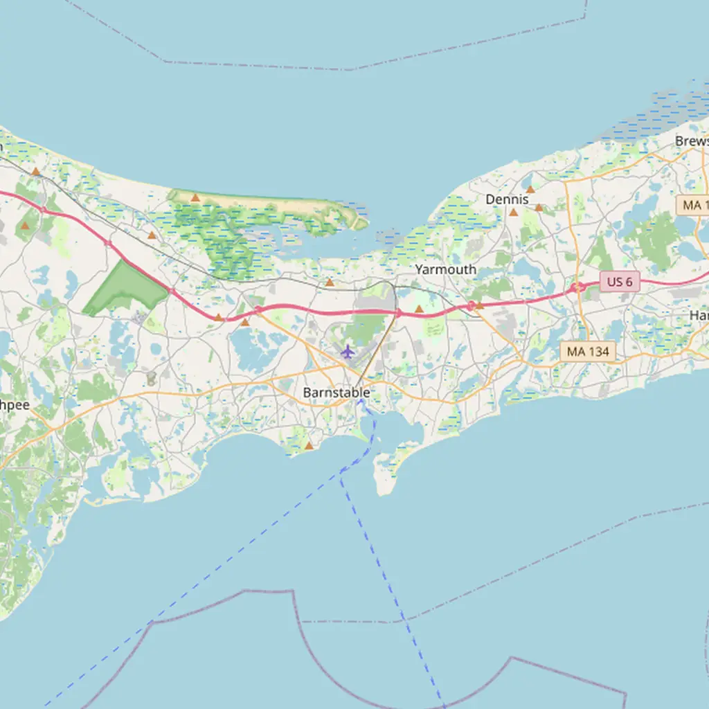
Aircraft noise around Cape Cod in November 2026
Loudest neighborhoods near Cape Cod: Hyannis, Hyannis Park, West Yarmouth, Yarmouth Port, Hyannis Port. Quietest: South Yarmouth, West Barnstable, Osterville, Marstons Mills, Cotuit. Busiest around 3 PM local time averaging 114 flights/day. Source: Flight Path Noise monitoring data, 30 days to 2026-11-09.

Does Cape Cod Airport have a curfew?
No — Cape Cod Gateway has no mandatory curfew, only voluntary quiet hours.
The airport is open 24 hours a day. It asks all operators to limit flying between 10 PM and 6 AM, but federal law does not let it enforce those quiet hours, so they are voluntary. Training, touch-and-go and certification flights need airport approval, and FAA airport data bars touch-and-go practice between 9 PM and 6 AM without the manager’s permission. Unscheduled airline flights with more than nine seats need prior permission between midnight and 6 AM. The airport says the few night flights are mostly weather delays, medical flights, early repositioning and mail.
Cape Cod Gateway Airport (HYA/KHYA) sits in the middle of Hyannis, in the Town of Barnstable, right on the Yarmouth town line. Known until 2021 as Barnstable Municipal Airport, it is owned by the town and run by an airport commission. It is a small airport with a steady mix of traffic: Cape Air and Nantucket Airlines shuttles to Nantucket, Martha’s Vineyard and Boston (the Nantucket run flies all year), seasonal airline jets in summer, and a large share of private jets, charters and light aircraft. The airport describes itself as landlocked, meaning there is no route in or out that avoids homes. It has two crossing runways, so noise falls along four corridors rather than one. There is no mandatory curfew, only voluntary quiet hours from 10 PM to 6 AM.
Which neighborhoods are quietest — and which aren’t
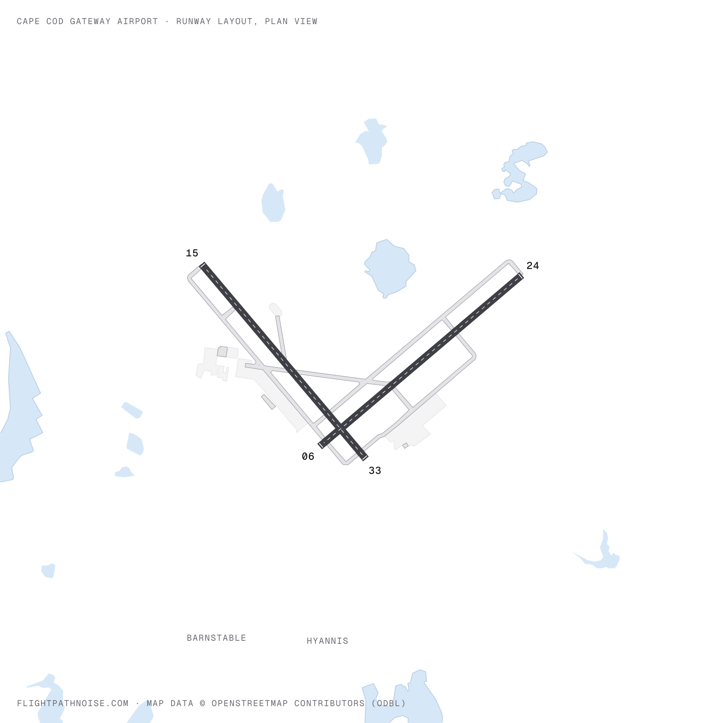
HYA has two runways of similar length, both with instrument approaches: 6/24 (5,425 ft), running north-east to south-west, and 15/33 (about 5,250 ft), running north-west to south-east. Extend each line out from the field and you get the four corridors that shape noise here: north-east over Yarmouth Port toward Dennis, south-west over Craigville and out over Nantucket Sound, south-east over Lewis Bay and Hyannis Park, and north-west past Barnstable Village toward West Barnstable.
The ratings below come from our own map data for the last 30 days, not from news coverage. For each village we sampled the modelled noise level and the route-density layer at its centre. High means a high modelled level plus a position under, or right beside, a corridor. Medium means a moderate level near a corridor. Low means a lower level and few tracks overhead.
The pattern matches what residents and officials have said. In 2023 the Boston Globe described a constant rumble of small planes over Lewis Bay, with Hyannis Park residents complaining of the noise, and in 2022 a Yarmouth selectman told the Cape Cod Times that most planes fly over Yarmouth even though the airport is in Barnstable. If you are looking at a home in Hyannis, West Yarmouth or Yarmouth Port, drop a pin on the map above before you decide.
Two other airfields sit inside the map. Cape Cod Airfield, a small town-owned field in Marstons Mills, adds light local flying. Joint Base Cape Cod is at the western edge, and its military traffic appears toward Mashpee and Sandwich.
| Area | Noise | Why |
|---|---|---|
| Hyannis | ✈︎✈︎✈︎ | Closest to the runways; highest modelled level we sampled |
| Hyannis Park | ✈︎✈︎✈︎ | Under the Lewis Bay corridor (runway 15 departures, runway 33 arrivals) |
| West Yarmouth | ✈︎✈︎✈︎ | Colonial Acres and the Lewis Bay shore, beside the south-east corridor |
| Yarmouth Port | ✈︎✈︎✈︎ | Directly under the north-east corridor, the busiest in our data |
| Hyannis Port | ✈︎✈︎✈︎ | Between the south-west corridor and the harbour approach |
| Craigville | ✈︎✈︎✈︎ | Under the south-west corridor |
| Barnstable Village | ✈︎✈︎ | Close to the field, beside the north-west corridor |
| Centerville | ✈︎✈︎ | Side-on to the south-west corridor |
| Dennis | ✈︎✈︎ | Outer end of the north-east corridor; aircraft higher |
| South Yarmouth | ✈︎ | Between corridors; Bass River side slightly busier |
| West Barnstable | ✈︎ | Outer north-west corridor, aircraft well above |
| Osterville | ✈︎ | The south-west corridor passes offshore |
| Marstons Mills | ✈︎ | Off the Hyannis corridors; light local flying from Cape Cod Airfield |
| Cotuit | ✈︎ | Few Hyannis tracks overhead |
Flight patterns and runway use
Which runway is in use depends on the wind and on air traffic control. The airport says it does not rotate runways or send traffic over any area to a quota. In good weather pilots are asked to follow the airport’s voluntary flight paths, which include:
- Runway 15 departures (south-east) turn to a heading of 140° toward Mill Creek, avoiding Hyannis Park and Colonial Acres where practicable. Nantucket flights cross the Great Island causeway; Martha’s Vineyard flights turn right over Lewis Bay and leave by the harbour mouth.
- Runway 24 arrivals from the north come straight in over Route 6, and all approaches to runway 24 are asked to avoid the Campgrounds area south-west of the Route 6 cloverleaf and Presidential Heights.
- Runway 24 departures heading south turn left over a golf course after 500 ft; others hold runway heading to 1,000 ft.
- Runway 6 departures hold runway heading to Route 6 and 1,000 ft before turning; those heading south keep east of the schools.
These procedures are voluntary under federal law, and they do not apply in poor weather, when controllers direct aircraft by radar.
In our recent data the north-east/south-west line of runway 6/24 is the busiest, especially out toward Yarmouth Port. The Lewis Bay corridor is the next busiest, carrying much of the island traffic. When one runway is closed for works, the other carries everything: in 2023, with a runway shut for maintenance, the Boston Globe reported that most traffic was coming in over Hyannis Park.
The airport’s 2022 master plan proposes lengthening runway 15/33. The project went through state environmental review in 2023 and 2024; check the airport’s environmental review page for its current status.
When is it quietest?
The control tower is open from 6 AM to 10 PM, and almost all flying happens in those hours. The airport is still open overnight, and its 10 PM to 6 AM quiet hours are a request, not a rule. The airport says night flights are kept to a minimum and are mostly weather delays, medical flights, early repositioning and mail.
The bigger swing is the season. The Nantucket shuttle runs all year, but in summer the airport adds seasonal jet services to New York, Washington, Philadelphia and Chicago. Private and charter flying is a big share of the total too: in 2023 the Boston Globe reported that nearly half of flights the year before were private or charter. The map above shows the last 30 days, so an autumn or winter reading understates what you will hear in July and August.
Wind matters too. A shift that moves traffic from runway 6/24 to 15/33 moves the noise from Yarmouth Port and Craigville to Lewis Bay and Barnstable Village.
How to check noise at your specific address
The map above answers “is this spot loud?” in three steps:
- Search your address or ZIP code in the bar at the bottom of the map.
- Drop a pin: click the location marker that appears.
- Read the noise report in the panel below the map: average daily noise (Leq), peak observed dB, flights per day loud enough to hear there, and an hourly breakdown.
The Noise Heatmap layer (orange/red = louder) and the Route Density layer (purple/magenta = busier corridors) show the cross formed by the two runways. Homes along those four lines are the ones to check most carefully.
To report noise, use the airport’s Noise Reporting Platform or the noise disturbance line on 888-422-7416. The airport’s flight-tracking portal lets you match an overflight to a specific aircraft. The airport began holding public noise roundtables in September 2026; questions go to noiseroundtable@flyhya.com.
This map is an independent modelled estimate. It is not an FAA Noise Exposure Map for HYA, and it does not decide eligibility for sound insulation or any other mitigation.
Frequently asked questions
- How do I make a noise complaint about Cape Cod Gateway Airport?
- Use the airport's online Noise Reporting Platform at planenoise.com/khya/dr4da54/, the Complaint Box Mobile app, or the noise disturbance line on 888-422-7416. Give your name and address, the exact date and time, where you were and any aircraft details. The airport checks the aircraft's altitude on its flight-tracking portal and refers cases below federal minimum safe altitudes to the FAA. Complaints are compiled monthly for the Airport Commission, the control tower manager and the airlines' chief pilots.
- Why do so many planes fly over Hyannis Park and Lewis Bay?
- Runway 15 points south-east toward Lewis Bay, and the airport's voluntary flight paths send departures that way, with Nantucket flights crossing the Great Island causeway and Martha's Vineyard flights turning over Lewis Bay to exit by the harbour mouth. Arrivals to runway 33 from the south use the same corridor. The airport asks pilots to avoid Hyannis Park and Colonial Acres where practicable, but in 2023 the Boston Globe described a constant rumble of small planes over Lewis Bay, and residents told it that conversations stop as they pass.
- Is Yarmouth Port under the flight path?
- Yes. In our recent data the busiest corridor is the extended line of runway 6/24, which runs north-east from the field directly over Yarmouth Port toward Dennis. Aircraft landing on runway 24 from the north come straight in over Route 6. Drop a pin on the map above to see your street's exposure.
- Is summer louder than winter at Hyannis?
- Yes. The Nantucket shuttle runs all year, but the summer schedule adds seasonal airline jets to New York, Washington, Philadelphia and Chicago. The map above reflects the last 30 days, so a reading taken in autumn or winter understates the summer peak.
- Can the airport ban night flights or fine noisy pilots?
- No. The airport says federal law prevents it from fining operators, restricting hours or limiting access for noise reasons, so its quiet hours (10 PM to 6 AM) and flight paths are voluntary. The procedures also stop applying in poor weather, when air traffic control directs aircraft by radar.
- Which Cape Cod villages are quietest for aircraft noise?
- In our recent data, Osterville, Marstons Mills, Cotuit, West Barnstable and South Yarmouth sit off the main Hyannis corridors. The most affected areas are Hyannis itself, Hyannis Park and West Yarmouth beside Lewis Bay, Yarmouth Port to the north-east, and Craigville and Hyannis Port to the south-west.
- Are military aircraft from Joint Base Cape Cod part of the noise?
- Joint Base Cape Cod is a separate airfield about 10 nautical miles west of Hyannis, at the western edge of the map above. FAA airport data warns pilots of high-speed military jet and heavy helicopter traffic near it. In our data its traffic shows up near Mashpee and Sandwich, away from the Hyannis corridors.
Sources and further reading
- Noise abatement, quiet hours and noise reporting — Cape Cod Gateway Airport
- Voluntary VFR flight paths — Cape Cod Gateway Airport
- Noise FAQs — Cape Cod Gateway Airport
- Airlines and seasonal flights — Cape Cod Gateway Airport
- AirNav — KHYA Cape Cod Gateway Airport (runways and airport remarks) — AirNav
- As Cape Cod aims to expand its underused airport, some residents wonder why — The Boston Globe
- An airport runway expansion is planned in Hyannis — Cape Cod Times
- Cape Cod Gateway Airport — Wikipedia — Wikipedia
Data updated 2026-11-09 — live ADS-B monitoring, rolling 30-day statistics (methodology). Article text revised 2026-11-08.
Other airports we track
All 174 airports →No airports in this region yet.